Each year in the United States, more than 350,000 people outside of hospitals have a cardiac arrest, and only about 10% survive.
In 2018, 67,367 drug overdose deaths occurred in the United States alone.
Rural police officers and firefighters have to deal with the threat or search for a person without proper information from air support.
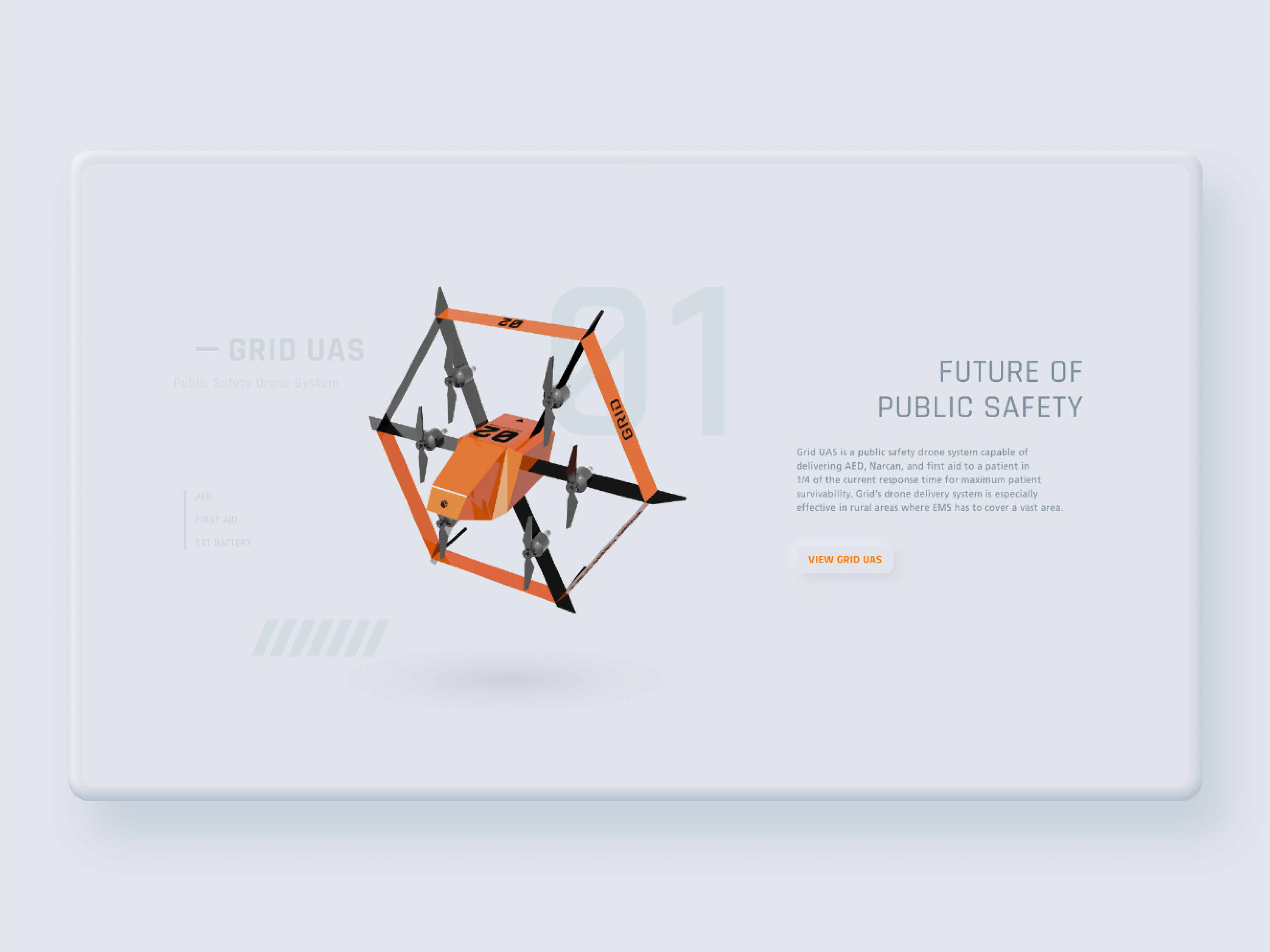
As a solution, I designed a CAD (Computer Aided Dispatch) system that allows dispatchers to dispatch drones to deliver AED or Narcan and assist police officers and firefighters by providing aerial footage.
Please watch video below for product walkthrough
Background
In 2019, I had a chance to learn about the current state of the public safety industry throughout my internship at Axon and designing an AR interface for firefighters. Unfortunately, I learned that some of the commercially available technologies such as drones are not benefiting the public safety industry at a scale it should be to help first responders save lives.
So in 2020, as my senior project, I decided to design a public safety drone CAD (Computer Aided Dispatch) system which allows dispatchers to easily equip drones with AED or Narcan and dispatch it to a call location in a 1/4 of current response time and assist police officers and firefighters by providing aerial footage.
What is CAD (Computer Aided Dispatch) system?
In the public safety industry, a CAD system plays an essential role by allowing dispatchers to dispatch units to a call location and update units with information given by a caller.
But this project was not aimed to replace existing CAD systems. unlike conventional CAD systems, Grid UAS is for dispatching drones, not units such as officers and firefighters. This makes a significant difference from conventional CAD systems because drones do not require a two-way conversation with dispatchers since they are not human and directly controllable.
Instead of replacing, Grid UAS meant to be used alongside existing CAD systems for only dispatching drones. But this also meant it was supposed to be designed to require the least amount of interaction to not make it as an additional burden to dispatchers. Also, the drone industry was fairly new in 2020 and existing delivery drones either didn't have a CAD system or developing in secrecy, and it leads to the challenge of designing something completely new from the scratch.
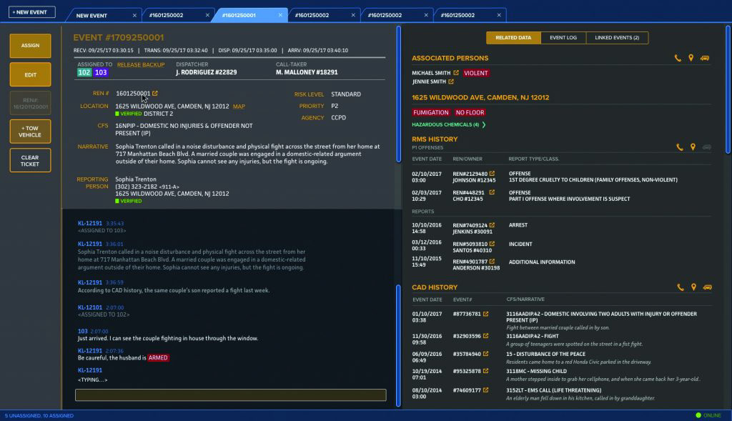
Latest CAD system by Mark 43
Market Research
At the beginning of the project, I researched existing products and published researches to validate the feasibility and potential of AED / Narcan delivery drone.
A Canadian study published in 2019 found that when compared to ambulances, using drones in the Toronto area cut AED delivery times in urban areas by 6 minutes, 43 seconds, and slashed it in rural neighborhoods by 10 minutes, 34 seconds in most cases. Likewise, a Swedish study published in JAMA last year showed that drones deployed in Stockholm took an average of 5 minutes, 21 seconds to reach their destination — more than 16 minutes faster than ambulances.
Studies also showed that this type of drone delivery system doesn’t require a whole lot of infrastructure. The AED would be sitting in a drone at all times, always rescue-ready. Even if it's a relatively large city, only a few stations can cover the whole city. For communities without the resources to implement a public-access defibrillation program, drone-delivered AEDs can be an extremely cost-effective way to fill a public health need.
Whether an individual has collapsed in the thick of a traffic jam, on a high-rise balcony, or at home or in the middle of a remote national park or in a rural location, if there’s a cell signal, a drone-delivered AED has the potential to save a life.
Source:
Industry Expert Interview
At the beginning of the project, I talked with local experts in the field of public safety and aerospace engineering to understand users' needs and technical constraints.

Dr. Chakraborty
Auburn University Aerospace Engineering faculty (designed cockpit interface)
• When it comes to public safety application every second counts, so a dispatcher should be able to easily find out about the drone's status (its range and equipment) to deploy suitable drone to the call location.
• When informations such as how long drone can fly (how much battery is left) are presented as numbers, dispatchers will have a hard time finding drones that can reach to the call location. Such kind of informations should be visualized on the map as circles to make it more intuitive.
• The biggest limitation when it comes to drone technology is the battery. Battery running drones cannot fly for a long duration of time. This means sometimes drones will not be able to make a round trip when it's sent to a faraway location or hovers the scene for a long duration of time. Yet drone may still be needed exceeding its battery capacity because lives depend on it for this application. For such cases, the system should allow dispatchers to dispatch drones as oneway, warn if the battery is low, and there should be a procedure to retrieve drones if it lands at the random location due to low battery.
• There should be no information overload and the system should display only relevant and essential information to prevent delays. For example, altitude may seem like necessary information, but if a drone is controlled by the autopilot, such information becomes irrelevant to a user and only clutters their view.

Lieutenant Rich
Auburn Police Department Lieutenant Officer
• Small department such as Auburn PD receives helicopter air support from larger cities, this takes up to 35 minutes to arrive due to distance and fuelling time. So most of the time, rural police officers have to work without air support.
• Auburn's police department utilizes DJI's Inspire drone to patrol the area during events such as game days (Auburn is a college town) to prevent car break-ins. Establishing police presence with a drone is very effective on lowering down the number of break-ins.
• Officers always must be aware of threats around themselves and this is why software tools such as CAD (Computer Aided Dispatch) systems can't be implemented on the smartphone and used on in-car laptops (using the softwares in a car provides more security).
• Officers on the scene won’t be able to manually control drones or view footages because they have to be aware of their surroundings and deal with threats. Instead, they have to be updated via radio communication by a dispatcher or an officer away from the scene who is viewing the drone footage.
• Police officers need reconnaissance information before arriving at the scene for their safety. Unfortunately, that is not the case today. Drone technology can solve such problem.
Chief Lankford
Auburn Fire Department Chief Commanding Officer
• For firefighting applications, drones can be used to read smoke’s color, direction, and velocity, which gives information regarding the fire (its spread, size, which materials are burning, etc...).
• At the fire scene, distributing limited resources is one of the main challenges for commanding officers. Live drone footage allows commanding officers to visually evaluate resource distribution by giving birds an eye's view with live drone footage.
• Drones can be used to survey the high-risk scene such as chemical contamination or gasoline tanks that may explode.
User Types (Persona)
Before the project, I thoroughly researched dispatchers, police officers, and firefighters' behaviors and pain points throughout internship at Axon (I designed CAD system by interviewing police officers and dispatchers) and Layer FD project (I designed an AR interface for firefighting application by interviewing firefighters). These are the listed findings of each user type that influenced my design decisions throughout the project.

Dispatcher
Dispatcher’s job is taking calls and dispatching units (police, firetruck, or ambulance) to a call location. They are also main users who need to equip and dispatch a drone to a call location. They are always busy and have to deal with multiple tasks such as taking calls, dispatching units, and updating narrative. Dispatchers also have to stay on the phone to receive information from and instruct a caller until EMS or police arrive on the scene. Since dispatchers are already burdened with multiple tasks, their interaction with the software must be minimal, and displayed information must be easy to understand.
Pain-points
• Multitasking with heavy cognitive load
• Lack of visual information from the scene (relying on the phone to communicate with a caller)
Goals & Tasks
• Equipping a drone and dispatching it to the call location
• Dispatching units to a call location according to call type
• Increase patient’s chance of survival by instructing a caller
• Providing necessary assistance to police and fire (i.e. looking up criminal search record)
• Relaying critical information to police and fire (i.e. suspect's description given by a caller)
Device
Multi-screen desktop
Police
Police officers are dispatched to a crime or violent activity and this makes their work dangerous. Their main objective is keeping the public safe by preventing crimes with police presence, and de-escalating the situation while keeping themselves safe. Air supports such as helicopter and drones can give them an upper hand in a dangerous situation by revealing a suspect's location without additional ground units and exposing themselves to danger.
Pain-points
• Responding to a call location far away or in the middle of heavy traffic
• Responding to a call without knowing the potential danger
• Waiting for air support for a long time to locate the suspect or fleeing vehicle
• Locating a suspect from the vast area with a limited number of units
Goals & Tasks
• Locating a suspect or person a missing person
• Establishing a police presence to reduce crimes
• Tracking fleeing vehicle while keeping civilians safe
• Recording the scene for evidence
• Identifying potential threat beforehand
• keeping citizens and themselves safe
• Responding to a call quickly to deescalate the situation
Devices
In-car tablet
Fire/EMS
Firefighter’s job is to contain & suppress the fire and rescue survivors in a car rack, structure, or wilderness. Recently many fire departments started to adopt drone technologies to evaluate resource distribution, smoke's behavior, a fire's spread, and locate survivors.
Many departments including the Auburn fire department offer Emergency Medical Service (EMS) which makes firefighters to also respond to medical emergency calls. They are responsible for keeping a patient alive by using basic medical equipment such as AED and Narcan until paramedics arrive on the scene. But such equipment may be utilized even earlier if a drone can deliver it.
Pain-points
• Responding to a call location far away or while in the middle of heavy traffic
• Working in hazardous environments such as chemical plant and gasoline station
• Dealing with fire or searching for survivors at the vast or remote area
• Searching for survivors in a dangerous environment
• Inability to assess how fire is spreading without air support
• Inability to visually evaluate resource distribution
Goals & Tasks
• Locating survivors in a dangerous, vast, or inaccessible environment without risking themselves
• Saving a patient’s life within a narrow time-frame
• Distributing limited resources effectively by gaining an overview
• Assessing smoke’s color, velocity, and direction to learn about the scale and spread of the fire
Devices
In-car tablet
Product Research
UAV control interface research
At the beginning of the project, I researched multiple UAV control interface including Lockheed Martin's military application "CDL system" and DJI's commercial drone control interface.
The majority of interfaces displayed an overwhelming amount of data such as altitude, throttle, pitch, latitude and longitude, and other countless information all at once.
These types of UAV control software granted more detailed control and customization but also requires a substantial amount of training time.
Since Grid UAS's target users are first responders and dispatchers, such a detailed interface model was not aligned with the user's goal and did not offer much value to the users.
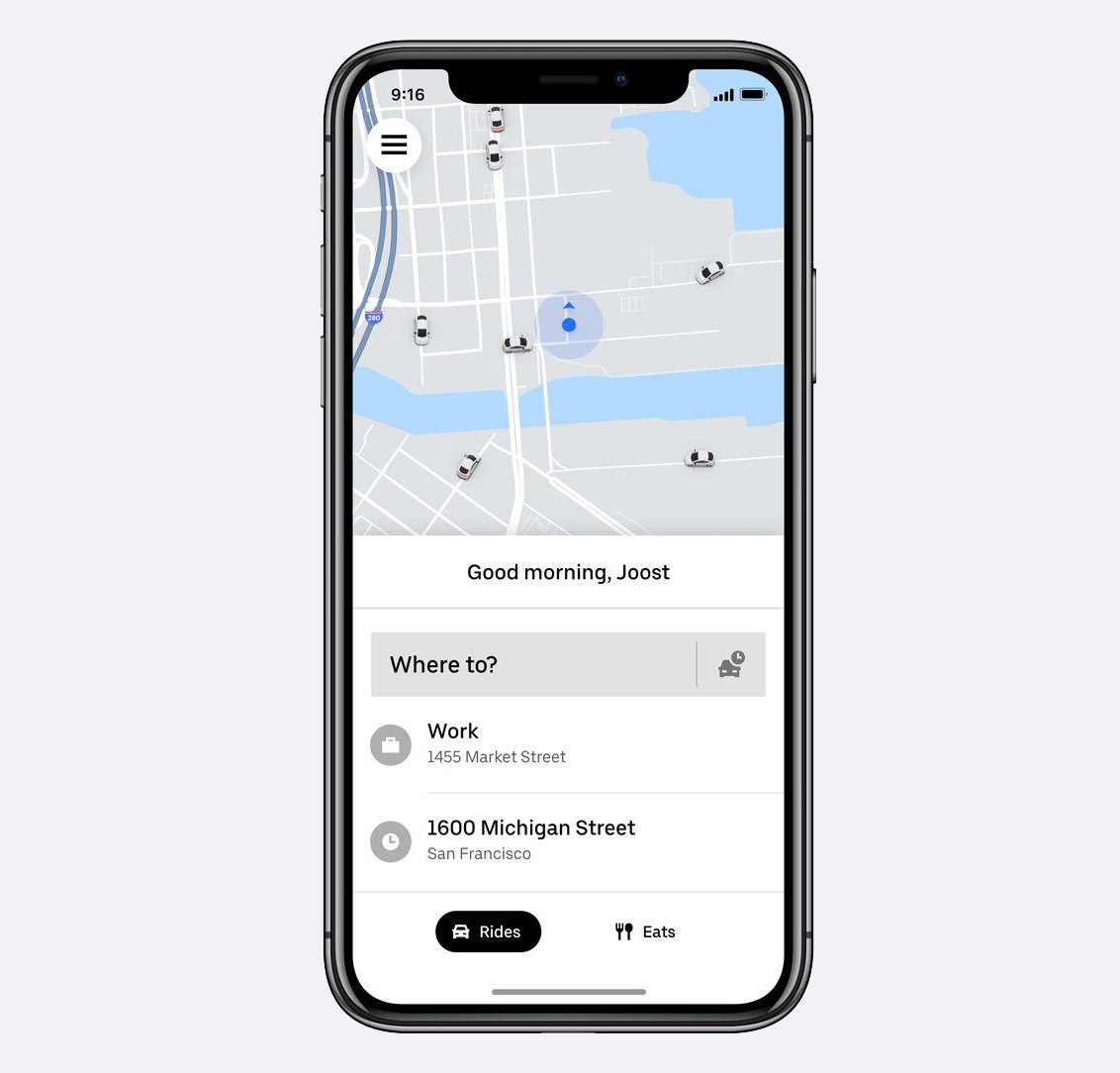
Uber's "where to?" model
To prevent information overload, I benchmarked Uber's "Where to" model to design an automated user experience.
Research shows dispatchers always multitask and manages multiple calls at once. This model allows dispatchers to simply type in the call location and select the equipment instead of having to cross-reference status, equipment, and range between drones by automating the process.
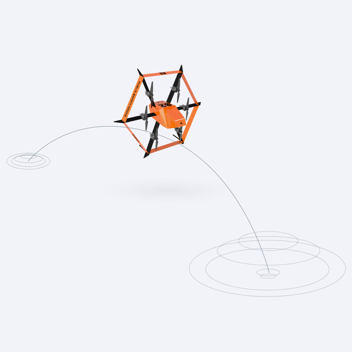
Just like Uber, once the system receives the address of the call location, the system will automatically locate the drone that is closest to the call location and dispatch it.
After the research, I designed Grid Dispatch, which is a CAD (computer-aided dispatch) system that allows dispatchers to easily equip and dispatch drones to a call location.
Design process
1. hardware & software scoping
2. User workflow
3. UI sketch
4. Establishing design patterns (a.k.a. component libraries)
5. Version 1 prototype based on 3 different user scenarios
6. Conducted tests with 3 local dispatchers
7. Made revisions based on the findings.
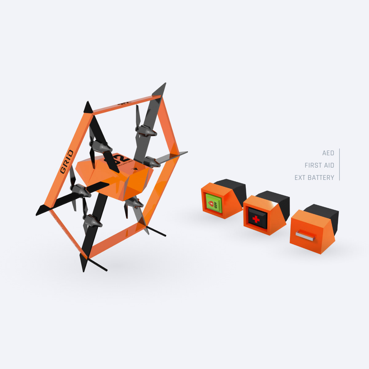
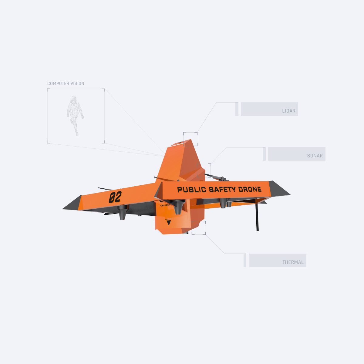
Hardware characteristics
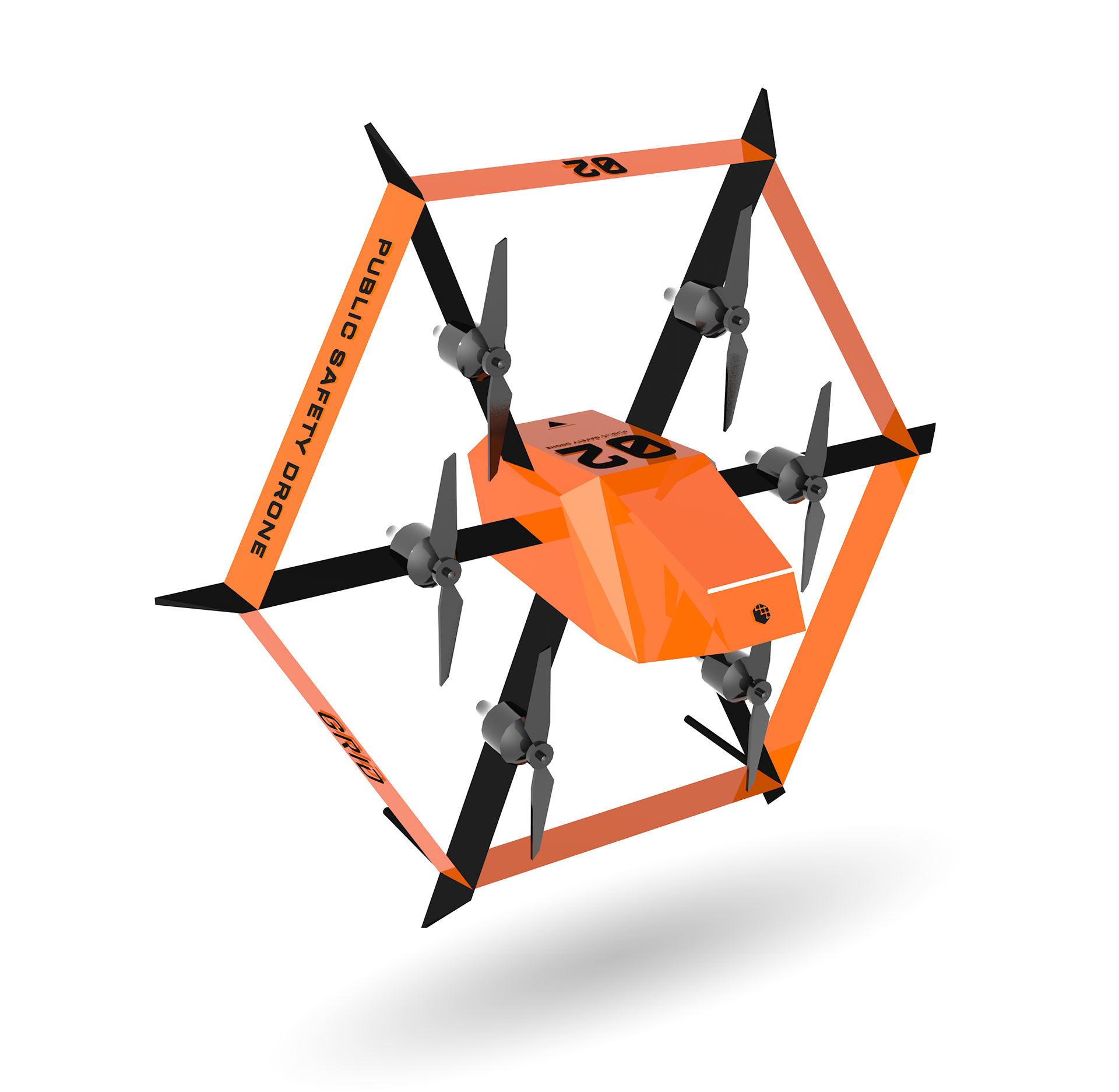
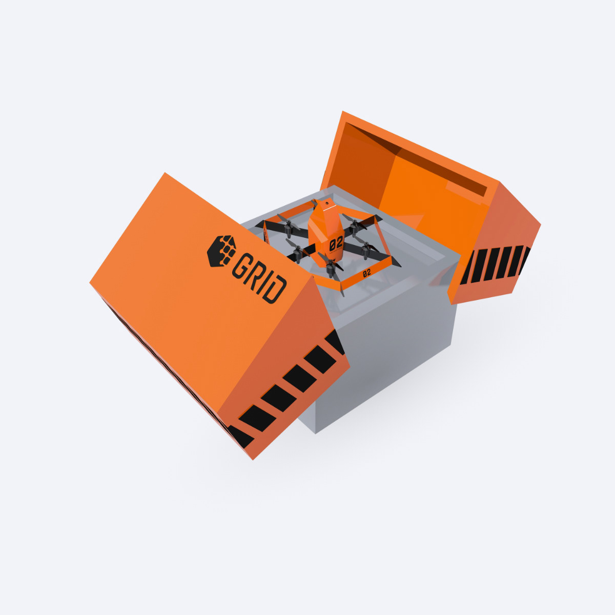
I'm not a hardware designer but at the beginning of the project, I defined drone's hardware characteristics and made a 3D model of a drone by using Cinema 4D.
The drone is designed to be equipped with different types of modules. This allows drones to carry the only necessary equipment which makes a battery last longer with lighter cargo weight.
To dispatch a drone, a dispatcher can select suitable equipment based on the context (i.e. AED for cardiac arrest) and input the call location on the system.
Multiple unmanned stations are located throughout a city. A station closest from the call location can automatically equip its drone with the equipment selected by a dispatcher. Once the drone is equipped, it will fly to the designated call location.
Scoping Equipments
After coming up with a hardware concept, I scoped drone's equipment to consider technical constraints first (i.e. cargo weight, safety, value, etc...). Based on Hick's law, to prevent delays coming from having too many choices, I narrowed types of equipment down to 3.
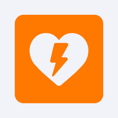
AED
Each year in the United States, more than 350,000 people outside of hospitals have a cardiac arrest, and only about 10% survive. But AED (Automated external defibrillator) can save a patient in case of cardiac arrhythmias by treating them through defibrillation.
AED is small enough to be delivered by a drone and the majority of households don't own AED. For this reason, AED delivery drones have been researched and developed for a while and it is what inspired me to start this project.
Scenarios
• Cardiac arrhythmias

First Aid (Narcan)
In 2018, 67,367 drug overdose deaths occurred in the United States alone. Narcan (Naloxone) can treat a narcotic overdose. Narcan comes in the form of a syringe or nasal spray. Its compact & lightweight makes it suitable to be delivered by a drone in case of a drug overdose. Narcan is included in first aid, which also includes a bleeding control kit.
Scenarios
• Drug Overdose
• Severe Injuries
• Uncontrollable Bleeding
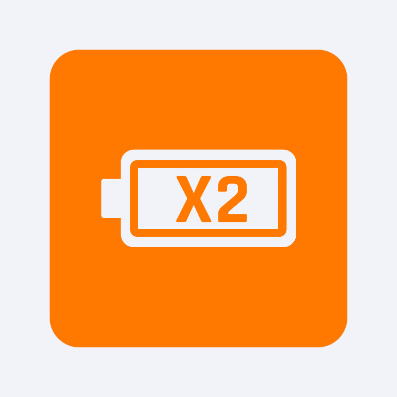
Extra battery
Grid's drones are aimed to not only deliver AED or first aid but also to assist first responders (searching for a subject, providing drone footage, etc...). But during the initial research, Dr. Chakraborty of Auburn's Aerospace Engineering department pointed out that drones have a low flight time due to battery capacity. This becomes problematic when assisting first responders requires a longer flight time.
So, I added an extra battery module that can be equipped instead of AED or first aid to give a longer flight time.
Scenarios
• High-speed chase
• Home invasion
• Search & rescue
• Structure or wild fire
• Kidnapping
• Any other scenarios that drone footages can be useful
Equipments that got cut out while scoping
Hummingbird
Hummingbird is a micro-sized drone I came up at the beginning. This drone is designed to be deployed from a larger drone to provide proximity drone footages such as indoor areas. With visual information of proximity live drone footages, dispatchers can better instruct a caller, or police officers can be notified about a threat around the corner. Hummingbird was cut off while scoping the equipment because it requires a person to hold a door or open a window to enter the indoor area. But later on, it inspired the "RP cam" concept (more on the RP cam below).
GPS tracker shooter
From 1996 to 2015, an average of 355 persons (about 1 per day) were killed annually in pursuit-related crashes. Road-chase endangers civilian's lives and causes property damages. I thought what if a drone can shoot a GPS tracker to a fleeing vehicle so the police won't have to endanger civilians and themselves to chase down the fleeing vehicle. This idea was cut out because making a drone to fly at low altitude at high speed to shoot GPS tracker seemed dangerous.
Survival kit
I initially thought it would be useful if a drone can carry a survival kit which includes space blanket, glow stick, radio, GPS, whistle, and water for search and rescue scenarios. I cut off this equipment because once a survivor is located by a drone, first responders can reach the survivor fairly quickly. Also, it made more sense to equip an additional battery in case of search and rescue scenarios so a drone can have a longer flight time when searching for a survivor.
Scoping Software Features
After defining hardware characteristics and equipment, I scoped software features based on it.
Dispatching a drone
Functions that allow a dispatcher to equip and dispatch a drone to the call location.
Create new dispatch: Research showed that dispatchers not only have to multitask but also deal with multiple calls at once. So I had to come up with a feature that allows dispatchers to easily start a new dispatch and manage multiple dispatches at once.
Selecting equipments: Once a caller explains the situation to a dispatcher, a dispatcher should be able to quickly equip a drone with the equipment that matches the context since every second count.
Address input field: Just like conventional CAD systems, Grid Dispatch requires an address to fly to the call location. To quickly dispatch a drone, address input field should be designed to assist dispatchers by guessing addresses or suggesting frequently dispatched addresses, similar to a Google map's address input field.
After despatch
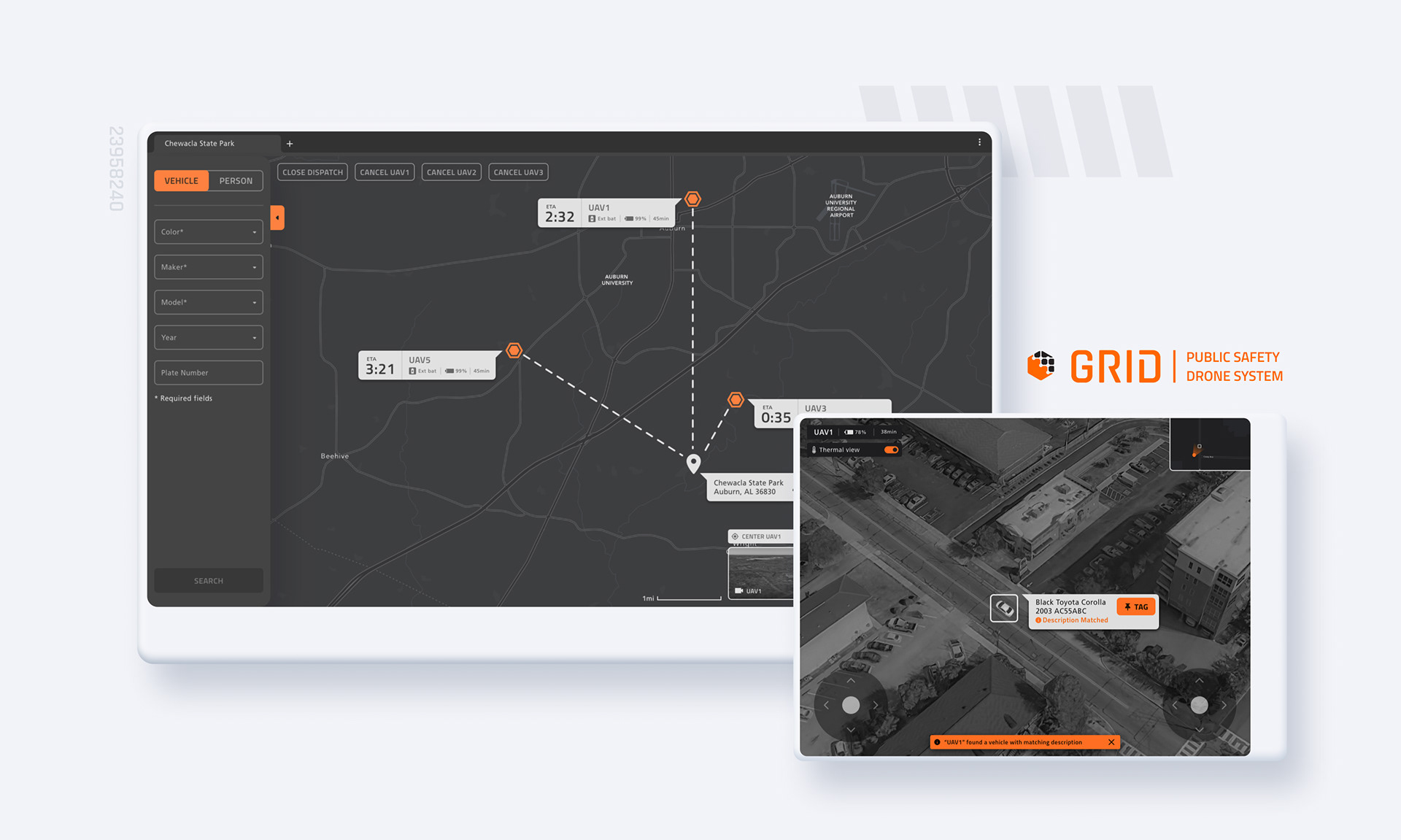
After a drone is dispatched, it automatically flies to the call location so a dispatcher can attend to other tasks instead of having to manually control it. But dispatchers should be able to view drone's status such as ETA (estimated arrival time) so they can update a caller how long it will take for a drone to arrive. They also should be able to view drone footage for scenarios such as search & rescue.
Drone's status & location (map): The system should display information about a dispatched drone so a dispatcher can update a caller about drone's ETA and show reassuring information such as drone's battery level, where it is sent from, and where it is heading.
Drone footage: In scenarios such as search & rescue or kidnapping, first responders should be able to view the drone's footage to locate a subject in a vast area. First responders can view drone footage on their tablet for such purpose, but in case they can't carry a tablet or must be aware of surroundings, dispatchers can assist first responders by viewing drone footage and updating via radio.
RP CAM: User research showed one of the dispatcher's pain point is trying to understand the situation at the scene without any visual information. Inspired by dropped feature "hummingbird," I came up with a camera glasses that can be worn by a person at the scene and live stream their view, so a dispatcher can instruct them better on how to apply AED or Narcan. On the software end, there had to be a feature that allows a dispatcher to view live stream on their computer.
Search
Dispatchers are always busy handling multiple tasks. But locating certain subjects such as vehicles or a person requires prolonged human attention. To change that, Grid UAS implemented a search feature to automatically search the designated area and locate a matching subject by using computer vision technology.
For this, on the UI, I added a search tab, which only appears when a drone is equipped with an extra battery. The search tab allows a dispatcher to input descriptions of a vehicle or a person and designates the search radius, which drones will fly over and look for a matching subject.
Laying Out Workflow
After scoping, I laid out a workflow based on 3 different types of equipment and software features. This allowed me to view the bigger picture and consider edge cases such as bad weather, no available drone, low battery, and canceling dispatch while in flight.
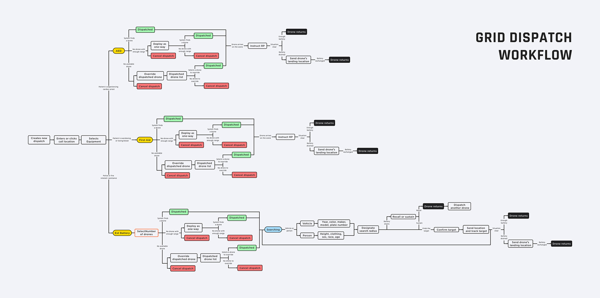
Prototype User Scenarios
To develop a prototype and test it, I came up with 3 different scenarios.
Final prototype walkthrough in cardiac arrest scenario
Cardiac arrest scenario
1. Types in the call location address
2. Selects AED as equipment
3. Dispatch a drone to the call location
4. [Drone arrives on the scene]
5. [Drone drops AED and heads back to the station]
6. Dispatcher instructs the caller to wear RP CAM (camera glasses)
7. Instruct a person on the scene how to use AED based on visual information
8. [Patient is revived]
9. [EMS arrives on the scene and the patient is transported to a hospital]
10. Closes the call
Final prototype walkthrough in home invasion scenario
Home invasion scenario
1. Types in the call location address
2. Selects Extra Battery as equipment
3. Dispatch drone to the call location
4. [System dispatches a drone that is already in flight by overriding its minor original task (i.e. patrol) since it's closest to the call location]
5. [Drone arrives on the scene and establishes police presence]
6. [System detects and warns about an armed suspect walks out from the house]
7. Alerts responding officers via radio
8. [The suspect gets in a vehicle and flees]
9. Tags vehicle, which makes a drone to follow it.
10. [System warns that battery level is at the half, which means if drone continues to operate, it will not have enough battery to head back to its station]
11. Relay vehicle's description and location to responding officers
12. [Police officers stop and apprehend the suspect]
13. [Drone's battery is drained, drone lands, and requests manual battery swap]
14. Radios ground units to swap a battery
15. [After the battery is manually swapped, drone heads back to the station]
16. Closes the call
Final prototype walkthrough in search & rescue scenario
Search & rescue scenario
1. Types in the call location address
2. Selects Extra Battery as equipment
3. Selects to deploy 3 drones
4. Dispatch drone to the call location
5. [3 Drones converge at the call location]
6. Input missing person's description into a search tab fields
7. Designates search radius
8. [A drone locates a heat signature with matching description, the system sends notification]
9. Tags a person and relays location to ground units
10. [Ground unit finds missing person]
11. Closes the call
Sketches
Before developing prototype I sketched ideas for layouts on a while board base on the scopes and user scenarios.
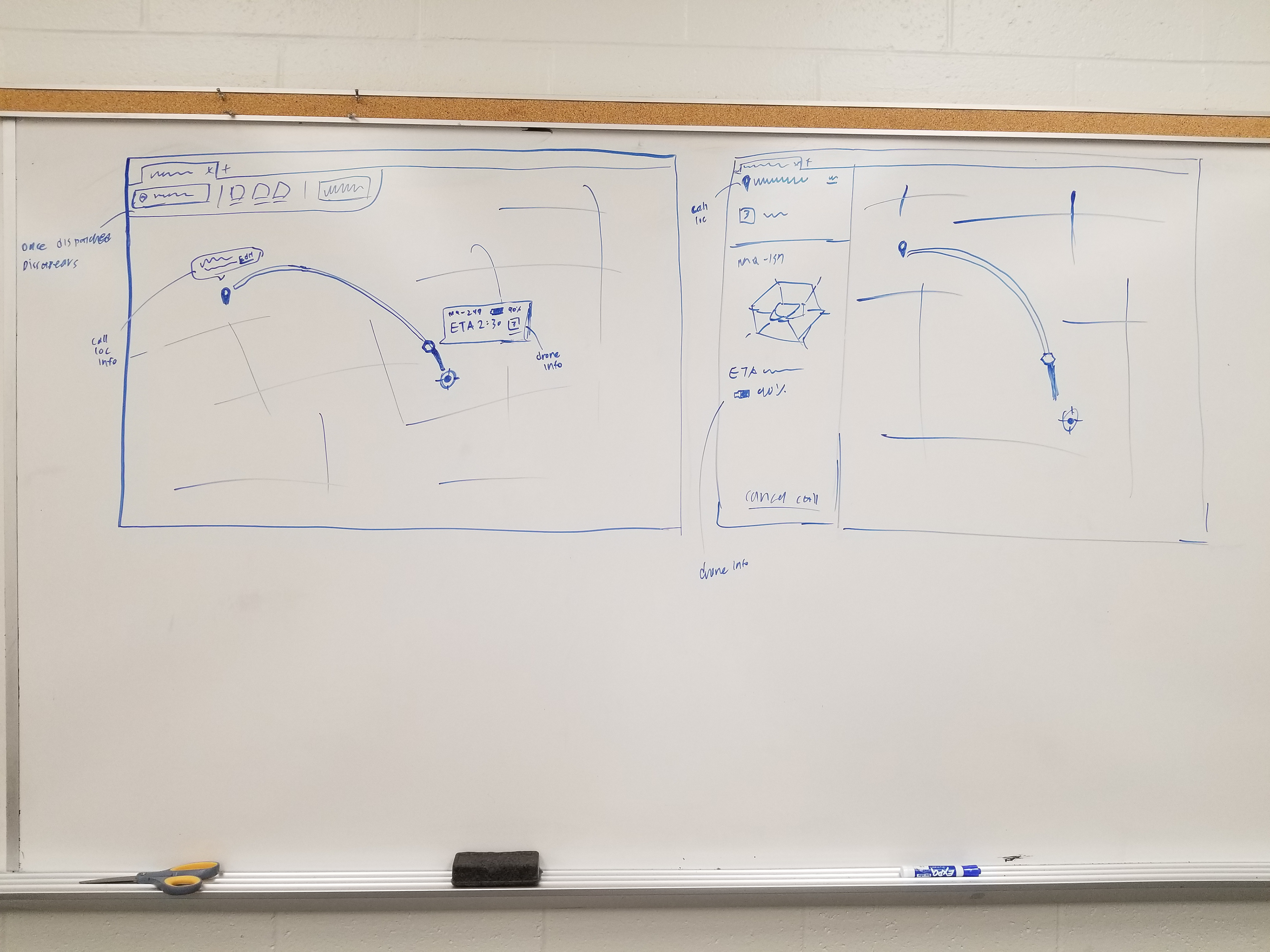
Brainstorming how to visualize drone's location and status on the map

Brainstorming subject search function
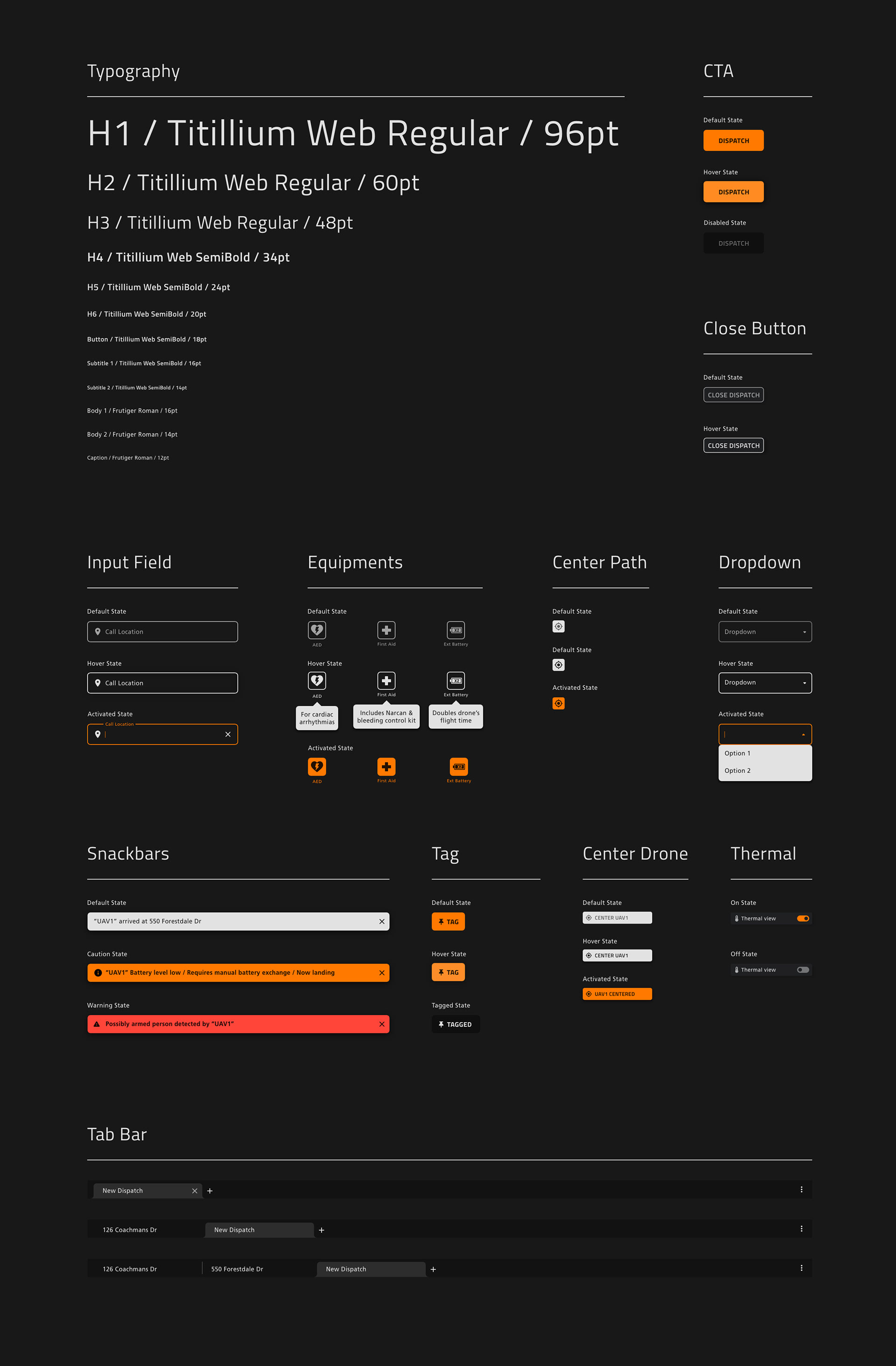
Establishing Design Pattern
Finally, I established design patterns (a.k.a. component libraries) to quickly create prototypes by assembling components and maintain consistent visual language throughout the screens.
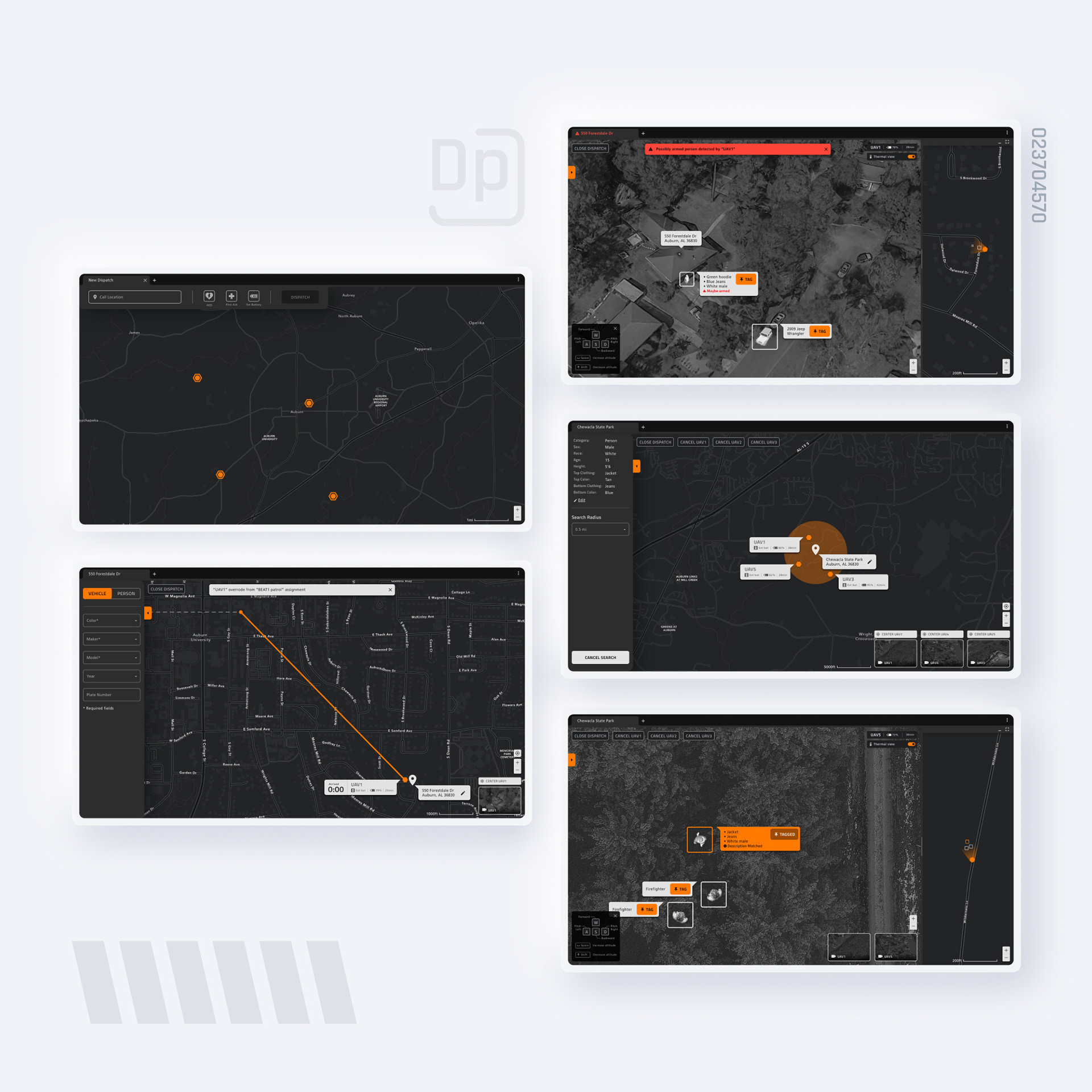
Final Design Walkthrough
Down below is the walkthrough of the final screens and changes I made based on the findings from the testing.
— New Dispatch —
Where every dispatch is started
A dispatcher can open a "New Dispatch" tab to dispatch a drone (similar to internet browser tab). "New Dispatch" screen has interaction similar to google maps, a dispatcher can either click the destination on the map or type in the address in the input field.
In emergency scenarios, seconds could mean the difference between life and death.
When a call comes in, a dispatcher can type in the address > select equipment > and click the "dispatch" button to send out a drone to the call location. Similar to Uber and Lyft, the system will automatically find and send out an available drone that is closest to the call location so dispatchers won't have to manually search for a drone that is suitable for deployment. This simplified interaction via automation takes less than 10 seconds to equip and dispatch a drone.
Tab bar system
Research showed dispatchers are aways busy multitasking (from taking calls to dispatching units) and they usually handle multiple calls at once. Because of it, I had to come up with a system that does not become an additional burden and allows dispatchers to easily manage multiple dispatches.
As a solution, I came up with a tab bar system which is similar to internet browsers such as Chrome. Each tab represents a call (a.k.a dispatch). This allows a dispatcher to easily start a new dispatch when a new call comes in and easily switch between multiple dispatches. By offering a familiar interaction that matches pre-existing mental models, software becomes more intuitive which requires less training time.
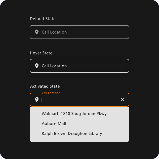
Call location input field
A drone needs an address of the destination in order to get there. To design software that cuts down response time by assisting dispatchers, the address input field is designed similar to Google Maps' and Uber's. The input field suggests the completed address as a drop-down based on the letters a dispatcher typed in.
During the user test, a dispatcher pointed out a lot of calls comes from locations such as Walmart or mall due to higher foot traffic. Base on this finding, I also added a feature that makes the input field to suggest frequently dispatched location as a dropdown when it is clicked.
Equipment components
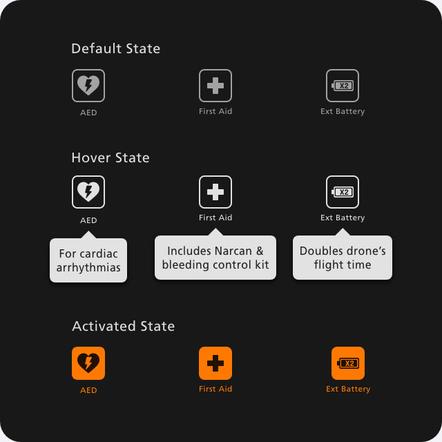
Based on Hick's law, to prevent delays coming from having too many choices, I narrowed types of equipment down to 3. The software displays these 3 different types of equipment as icon buttons. A dispatcher just needs to click an icon of equipment based on the context (i.e. AED for cardiac arrest).
During the testing, all 3 dispatchers who participated in a test struggled to understand the icon's meanings. Based on this finding, I added a feature that displays an explanation of equipment as a speech bubble when the mouse cursor is hovering.
Dispatching multiple Drones
For scenarios such as search & rescue or kidnapping, deploying multiple drones to search for a subject is more efficient than relying on a single drone. That is why on the new dispatch screen when a user selects an extra battery as equipment, an additional dropdown will appear. This dropdown allows users to select the number of drones that will need to be dispatched at the scene.
This feature only appears when an extra battery is selected as equipment because a single drone can deliver AED or first aid but deploying multiple drones can be useful in the scenario when an extra battery is equipped.
— After Dispatched —
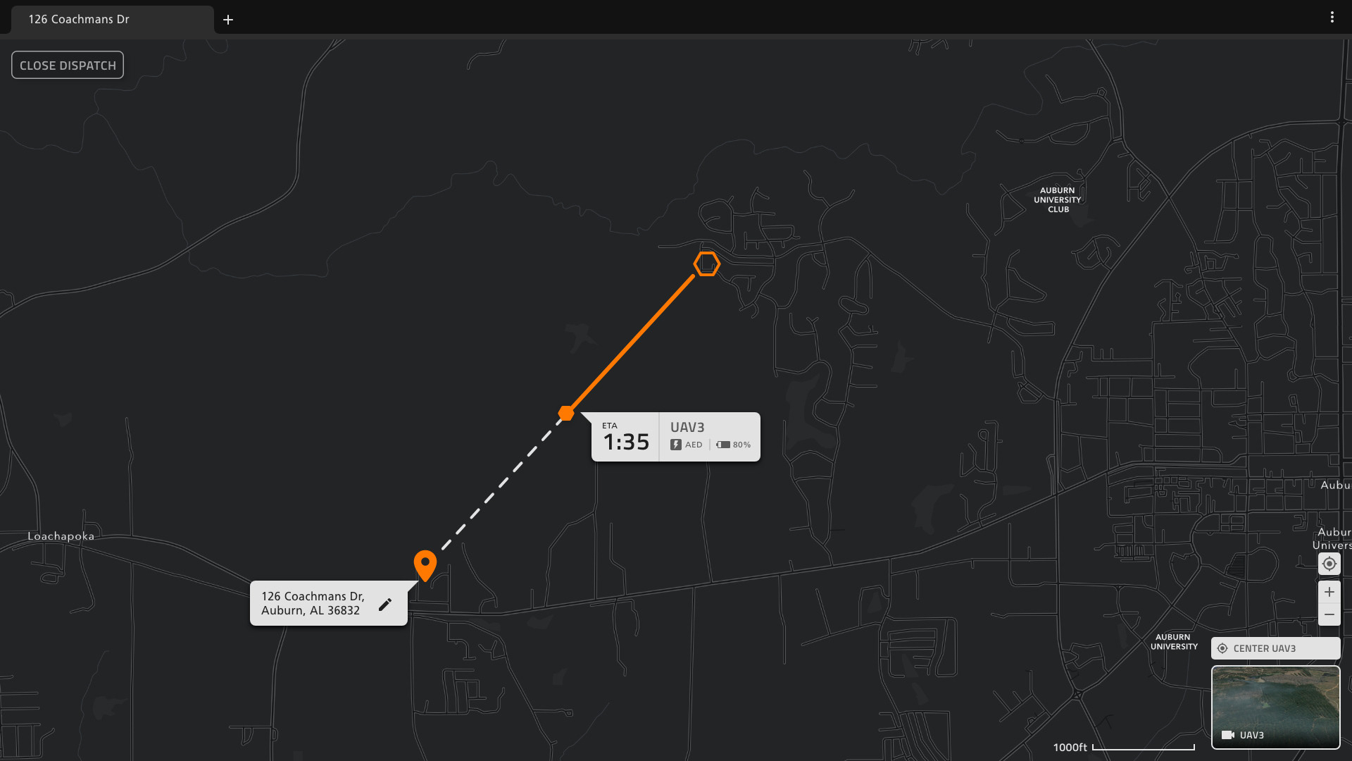
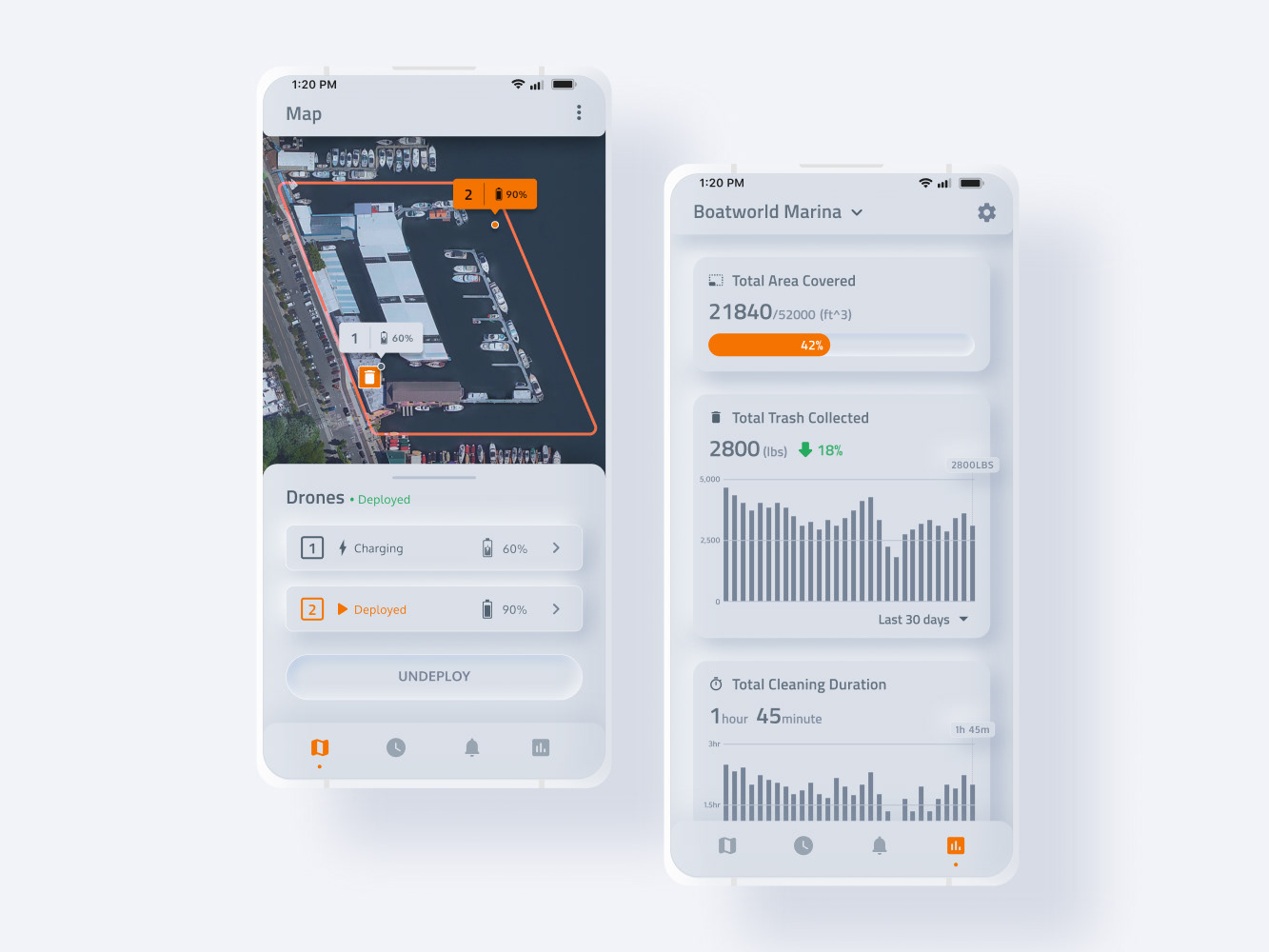
Map screen when a drone is dispatched with AED or First Aid
When a drone is dispatched it will automatically fly to the call location so a dispatcher won't have to manually control it. But the map screen will display reassuring information such as battery level, its location on the map, and type of equipment. It also displays drone's ETA (estimated time of arrival) so a dispatcher can update a caller how long it's left until drone arrives. A drone's camera view is displayed as a thumbnail on the bottom right corner and it can be displayed as a full screen when clicked.
Information such as altitude, speed, coordinate, range is not displayed since such information doesn't offer much value to dispatchers because a drone is auto-piloted and to prevent information overload.
When the drone is dispatched with Extra Battery "Search Tab" appears on left
When an extra battery is selected as equipment, a search tab will appear on the left side of the map screen. Scenarios such as search & rescue require prolonged human attention to identify a subject. But research showed dispatchers are always busy handling multiple tasks.
To alleviate this pain point, the search tab allows a dispatcher to input descriptions of a vehicle or a person and designates the search radius. Then drones will fly over the designated area to look for a matching subject by using computer vision technology and alert a dispatcher when it finds a matching subject. This allows dispatchers to handle tasks instead of having to stare at drone camera footages.
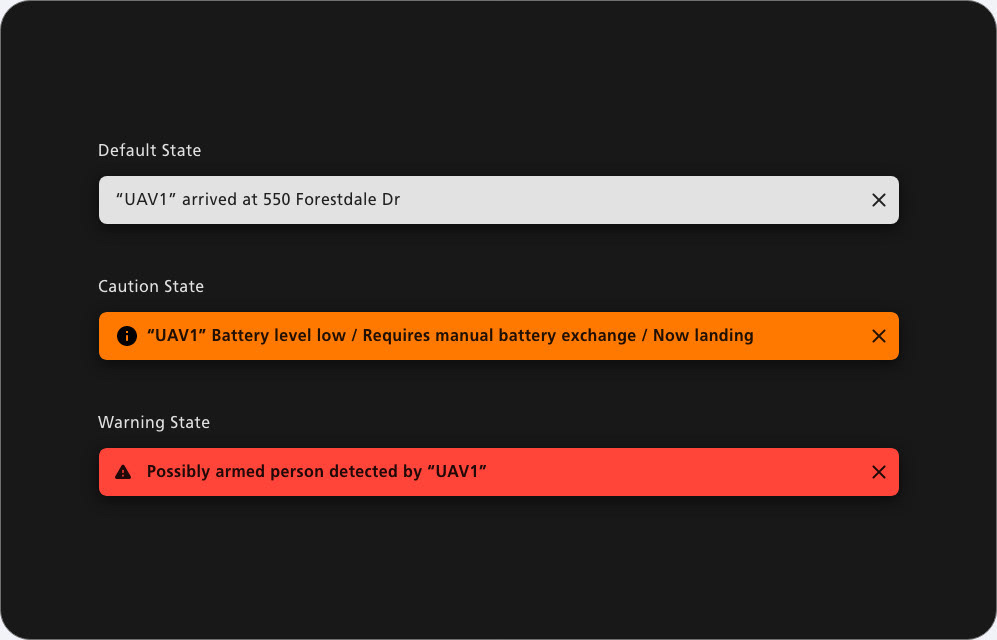
Snackbar components
Snackbar appears when there is an update on the drone's status to acts as a notification. There are three different categories of snackbars to indicate notification's severity.
• Default State: a normal notification (i.e. drone arriving at the call location)
• Caution State: a notification regarding the update that has an impact on drone's mission (i.e. low battery, finding a person or vehicle with matching description, bad weather, etc...)
• Warning State: a notification regarding serious escalation (i.e. drone getting attacked, detecting a gunshot, identifying an armed person, etc...)
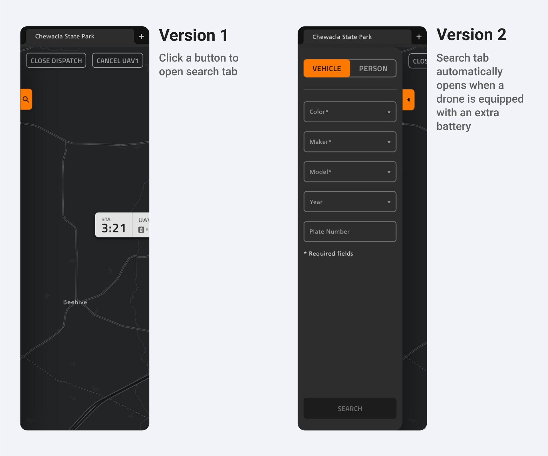
Automatically opening search tab
In version 1, I designed the search tab to appear when a button on the left side of the screen is clicked. During the testing, when I asked dispatchers "where would you input the description of a missing person," all 3 dispatchers struggled to find a button that opens the search tab. The search tab button was too small to be noticed and the function of the button didn't convey clearly.
Based on this finding. I made search tabs to be already opened when a drone is dispatched with an extra battery equipped. This is because scenarios when a drone is dispatched with an extra battery (i.e. kidnapping, search & rescue, etc...), are the scenarios when search functions will be used.
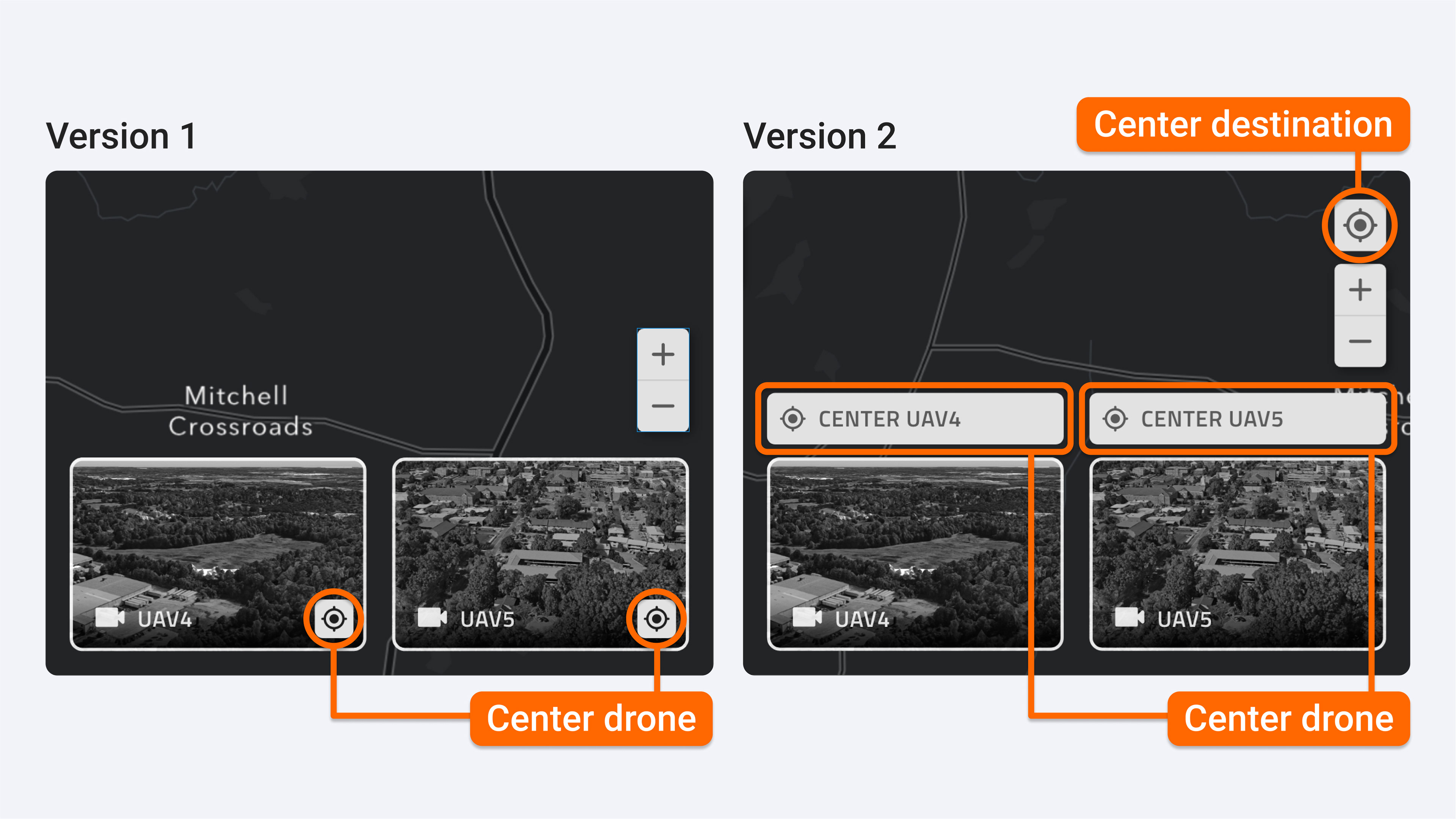
"Center on drone's location" button
Just like Google Maps has a "center on my location" button, there is a button for centering drone's location on the map.
But a challenge was, unlike how Google Maps only need a single button for centering a user, on Grid Dispatch, multiple drones can be active at once. This requires multiple "center on drone's location" buttons, associated with each drone.
That is why on version 1, I nested "center on drone's location" button inside of each drone footage thumbnail button. But during the user test, all 3 dispatchers struggled when I asked them to center the drone's location on the map. Nesting a button within an already clickable element created confusion and thumbnail image made the button less visible.
Base on this finding, I made "center on drone's location" buttons more visible and intuitive by placing them above thumbnails and explicitly describing the button's function.
— When the Drone Arrives at the Scene —
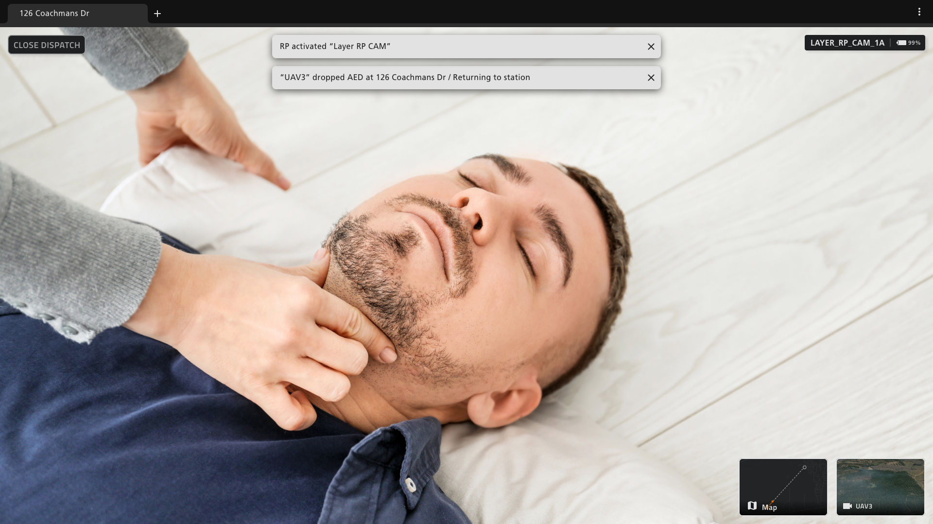
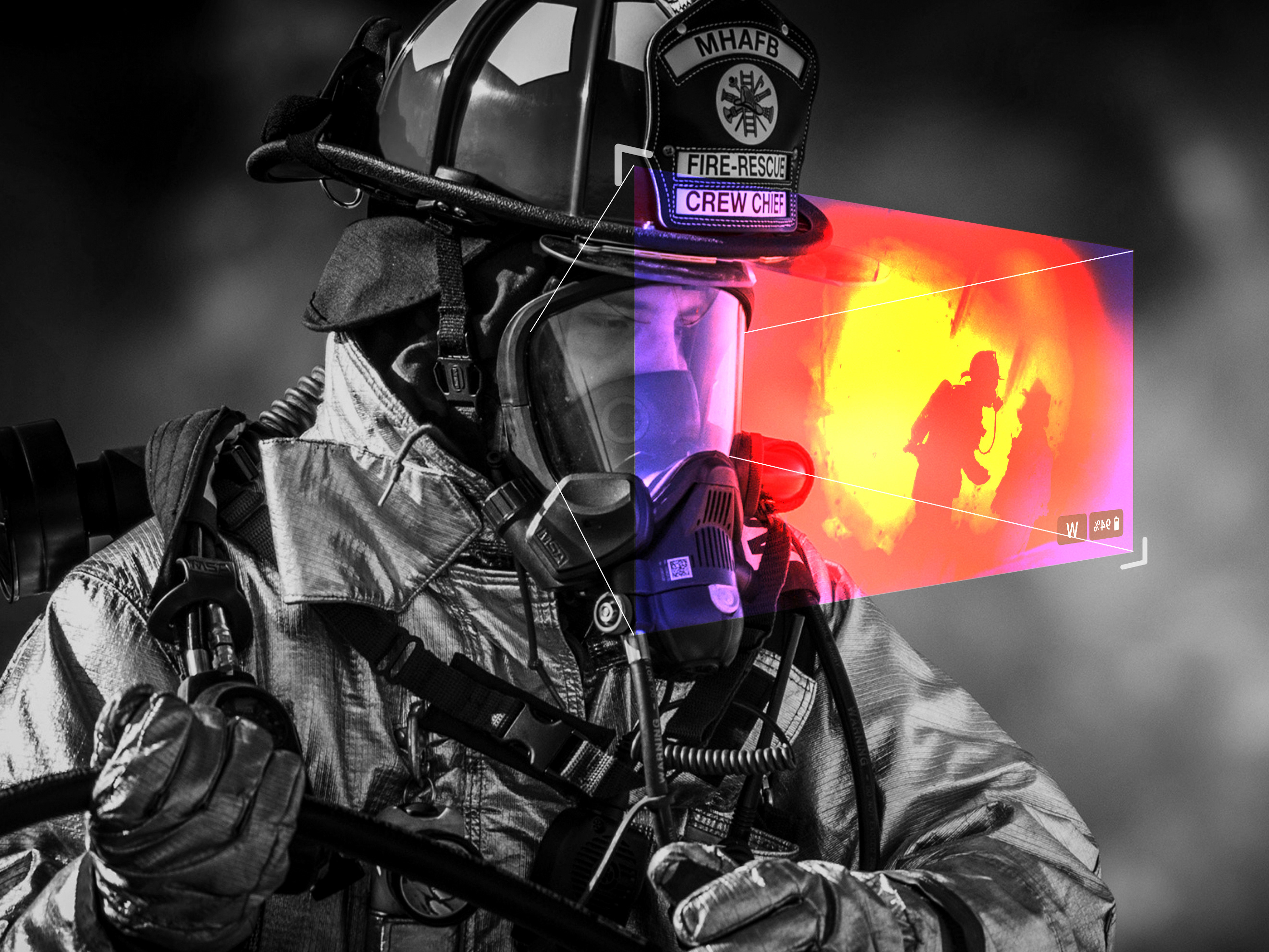
AED and First Aid include a camera glasses called "RP CAM"
User research showed one of the dispatcher's pain point is trying to understand the situation at the scene without any visual information. To alleviate this pain point, I came up with RP CAM, a camera glasses that can be worn by a person on the scene and live stream their view to a dispatcher.
By turning a camera into a wearable device, a caller can live stream their view while attending a patient by keeping their hands free. When RP CAM activates, the software will display the live view in a full screen so a dispatcher can instruct the caller on how to apply AED or Narcan based on the visual information.
Version 1 (before testing)
Version 2 (after testing)
Live drone footage screen
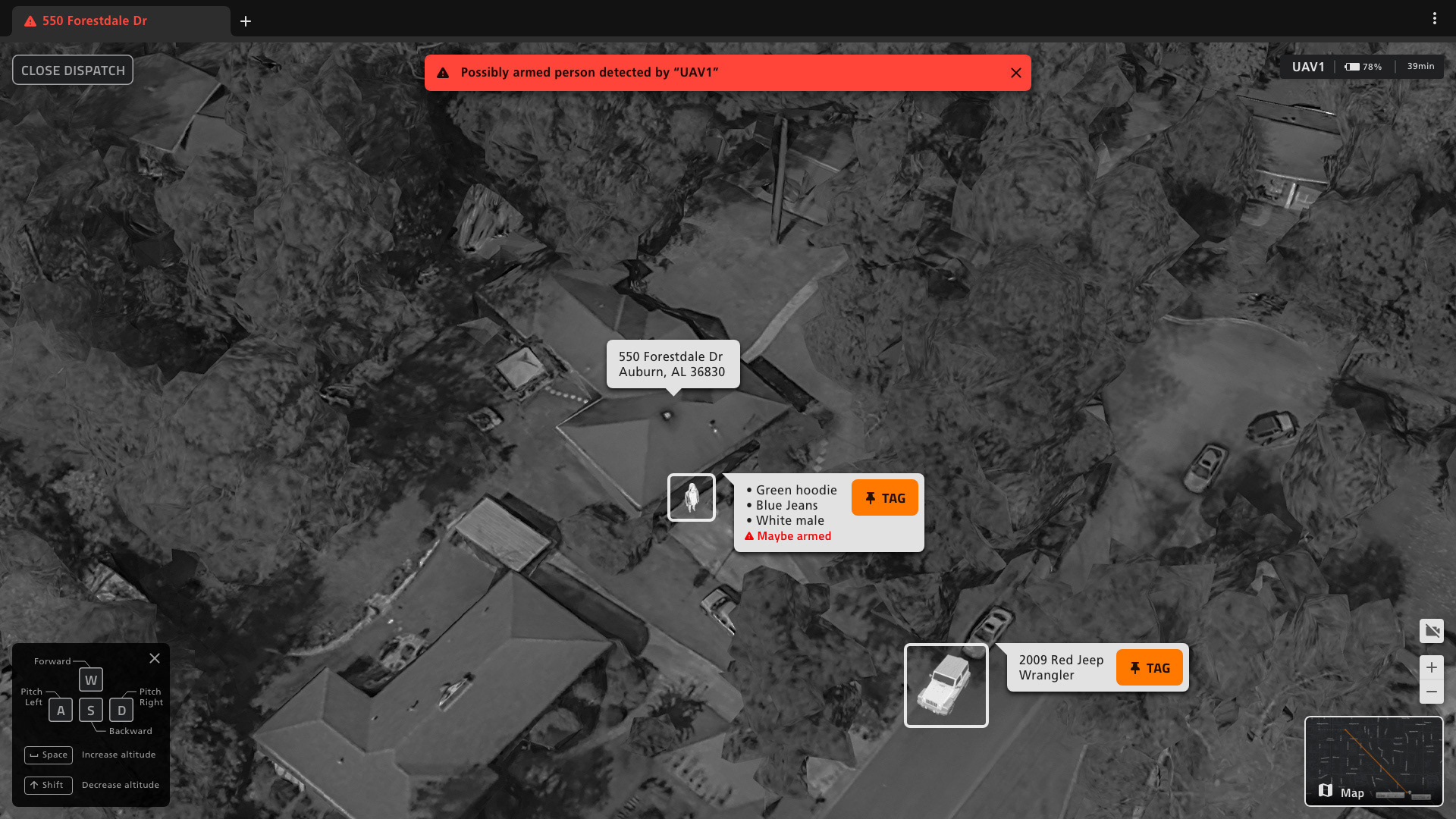
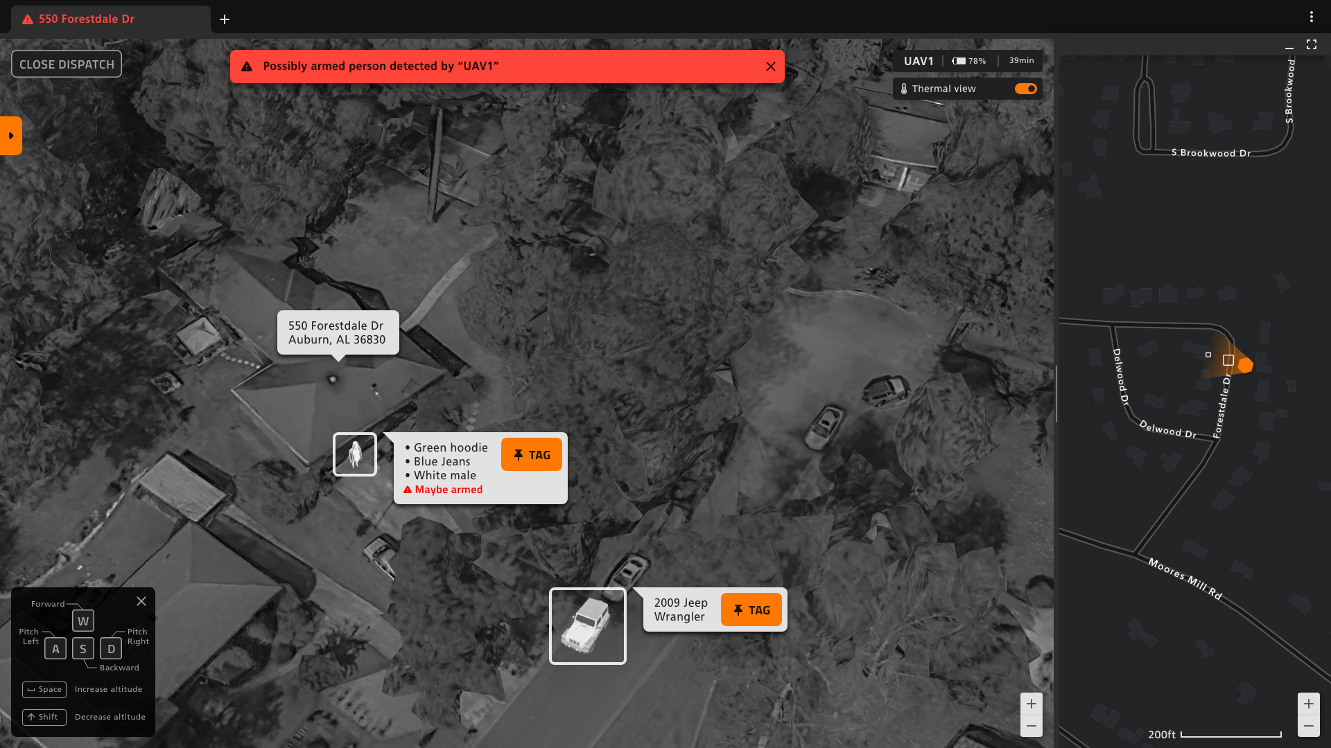
For scenarios when a drone is dispatched with an extra battery (i.e. search & rescue, home invasion, etc...) drone's camera becomes a crucial tool. On the live drone footage screen, the system will display a drone's camera view, mark subjects with squares, and display subject description by identifying it with computer vision and heat signature. A dispatcher can tag a marked subject by clicking a tag button. If a subject is tagged, a drone will automatically follow a tagged target so a dispatcher won't have to manually control the drone.
While testing the prototype, all 3 dispatchers were looking for coordination of a drone to make sense of drone's current location so they can relay the suspect's location to officers. Based on this finding, I added a map on the right side of the screen to display a drone's location on the map and the direction it's looking at.
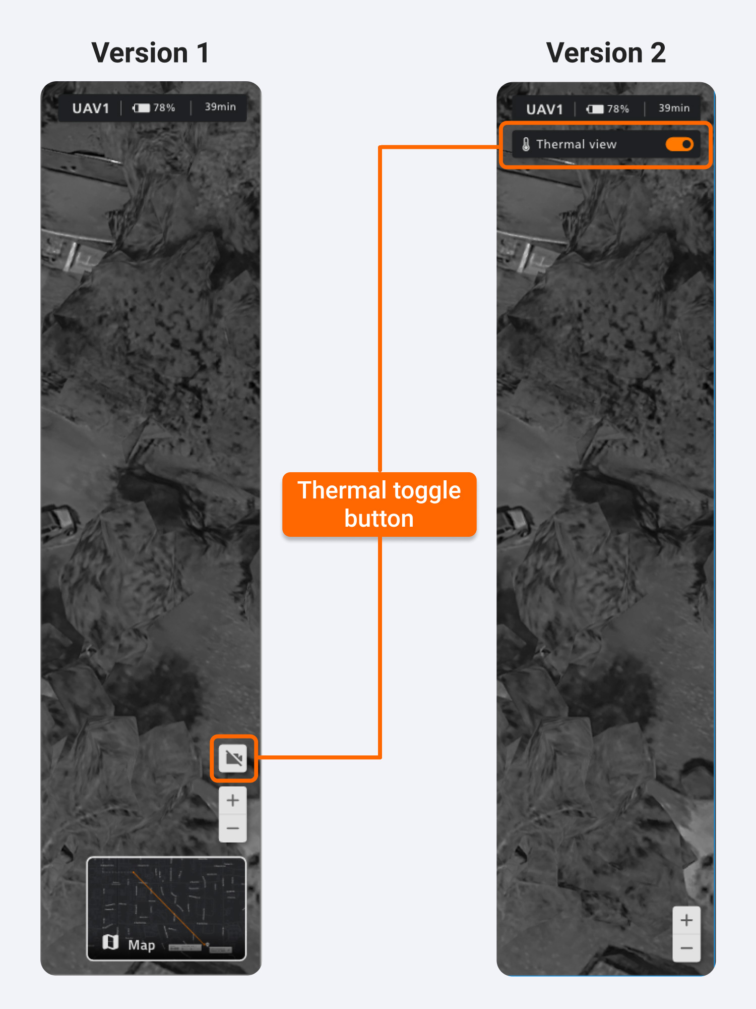
Thermal toggle button
On the live drone footage screen, there is a thermal toggle button for turning on/off thermal imaging. In version 1, I made it as a camera icon but during the test, when I asked "How would you turn off the thermal view?" all 3 dispatchers failed to find a way to turn it off. Base on that finding, I changed it into a form of toggle button and stated its function clearly with a temperature icon.
Conclusion & Takeaways
If Grid UAS was a real product, there can be countless pitfalls such as hardware malfunction, FAA regulations, privacy concerns, reliability of artificial intelligence, etc... Since this project was a concept project, it's impossible to tell what kind of implication this interface I designed will have when I can't observe how it will work with accompanying hardware and artificial intelligence.
In terms of testing, 3 local dispatchers I who helped me with the user test gave positive feedbacks. I was surprised by how all of them were able to interact with the core features of the software with little explanation and zero training. Though Grid Dispatch is different from conventional CAD systems, it was a significant improvement given how some of them require 6 months of training.
This taught me designing professional software tools around users' pre-existing mental models (designing similar to familiar consumer products) and simplifying interaction with automation can dramatically reduce the training time. I wish I could conduct another round of user tests with the improved prototype I made after the first testing. But due to the Covid-19, I was unable to do so.
I would like to thank Auburn University's aerospace engineering faculty members and the City of Auburn public safety department's dispatchers and first responders for helping me conducting research and test throughout this project.
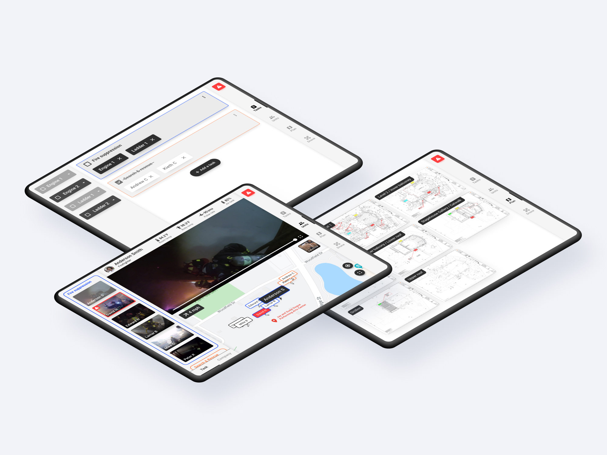
Grid Field
Grid Field is a tablet variant designed for ground units (police and firefighters) and shares the majority of features with Grid Dispatch. Grid Field allows ground units to request drones and view a drone's camera footages to utilize it for patrol or scenarios such as search & rescue.
This part of the project was cut short due to Covid-19, and I was unable to test the prototype and make iterations. But you can view the screens clicking a button below.